Topbanner
blue line
line
line
line
line
  C. Other Examination / Investigation Reports
 
 
12. A Geotechnical Opinion on Basis of the Underwater Documentation (ROV) of 29.08.00
by Dr. Jan Laue/Technical University, Zürich
 

The expert on soil mechanic, Dr. Jan Laue, was asked to explain the apparently abnormal condition of the seabed in way of the starboard mudline and the forward part of the wreck – see also 2.3.8.1.

He received for this assignment the complete documentation available to us, among other things, the contracts and project description as well as the “detailed Report on Deformation during Sand Filling” all in connection with the work to cover the ESTONIA officially called “The Protection of the Estonia”. His analysis of this quite substantial documentation revealed the following condition of the sea bottom below and around the ESTONIA.

(a) According to statements from the divers in 1994 and the examinations from 1996 the sea bottom consists of muddy sediments respectively boulder clay, which is a clay-sand mixture.

(b) The sea bottom is wavy with a water depth of between 60-90 m around the ESTONIA. In some of the valley areas rather soft clay areas were found during the 1996 examinations which were analysed by the Geotechnical Institute Delft and which should be similar to those layers into which the ESTONIA wreck did partly penetrate.

(c) ROV footage from 1994 shows scattered stones and occasional rocks.

(d) It was reported that until 1996 the ESTONIA was apparently lying on a rather stable area of the sea bottom, probably boulder clay capable to bear the load of the wreck.

(e) The measurements subsequently performed to check the thickness of the sand fill, revealed, among other things, that the sea bottom in way of the ESTONIA was declined by 10 m in the aft forward direction, i.e. the bow is 10 m deeper than the stern.

note  

Note: This finding is contrary to the Smit Tak Report No. 94/7.060 produced after the diving/ROV surveys in December 1994 where it is stated on page 6 : In longitudinal direction there is little to no trim.”

(f) Contrary to the apparently stable condition of the ESTONIA, measurements ascertained that the sand fill in the surrounding of the wreck settled into the muddy bottom.

(g) The sand-fill operation itself is explained as follows:

  • The sand-fill area around and excluding the near vicinity of the wreck was at first covered by mats of geotextiles spread out and fixed at the edges by means of penetration strings (rocks or other heavy objects) to the sea bottom.

  • The subsequent phase of the sand filling is well documented. Surveys carried out simultaneously with the sand fill showed that the sand locally disappeared and did not cover the textiles.

  • Also the gap between the separate mats could not be closed.

  • Based on the well documented area supposedly sand filled, the enor-mous size becomes visible which explains that in spite of the huge quantity of 380606 m³ of sand dropped down the thickness of the sand layer is only 10-30 cm, sometimes 0.

  • Further it was established that the immediate surroundings of the wreck and the wreck itself were not intended to be covered and indeed were not covered by geotextiles and sand in 1996 according to the available documentation.

(h) The sand-fill respectively covering operation was stopped in June 1996 and based on the available documentation no further sand fill should have been carried out.

note  

Note: This is indeed the position reported by Sjöfartsverket to the public up to date. (See Der Spiegel No. 3/2000.)

Consequently it can be concluded that according to the relevant document-tation the immediate vicinity of the wreck and the wreck itself were neither covered by geotextiles nor by sand, which however is wrong because:

(1) Based on the video footage produced in August 2000 it has to be concluded that further sand fill had been carried out, after June 1996 and before August 2000, because the sand is now extending to the wreck in particular in the foreship area and to the layer measured in June 1996.

(2) The tracks of vehicles on wheels having moved across the sand layer indicate that this sand must be rather light, i.e. has not been there for years but more likely for only months, if at all.

(3) The unknown vehicle traces were consequently created subsequently, i.e. after the latest sand fill.

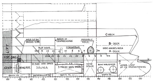
As already stated the latest sand fill extends to the hull side and, as far as it has been established by the ROV inspection in August 2000, the sand layer has a relatively homogenous height alongside the mudline in the forward part of the wreck with exception of a crater in way of the void space on the drawing below – see arrow.

0164_v2
  enlarge  

In the following the expert explains, why it has to be assumed that additional sand had been filled up alongside the forward starboard side of the wreck and why the observed cave cannot have been created during the sand-fill operation. He further explains that the relatively small size of the cave leads to the conclusion that it was not caused by hollow spaces in the underground and/or below the wreck but that the most likely cause is an opening in the hull below the fender bar.
For further details reference is made to the Report of Dr. Jan Laue (in German) which is attached as Enclosure 9.

In summary of the above it has to be concluded that

(a) There has been an additional sand-fill operation after July 1996 and before August 2000 about which the public has not been informed.

(b) By this sand-fill operation the space between the cover area projected (and approved) and the wreck was filled up with sand presumably only in the foreship area.

(c) There is a hole several cubic metres big below the fender bar in way of the cave in the otherwise rather homogenous seabed level.

(d) This hole is located in way of the forepart of the car deck of the ESTONIA above the void space in the double bottom – see the drawing on the previous page.

 
arrow left sitemap arrow right